On this page:
About the project
Offshore wind will play a major role in Victoria’s energy transition - and Gippsland has some of the best wind resources in the world.
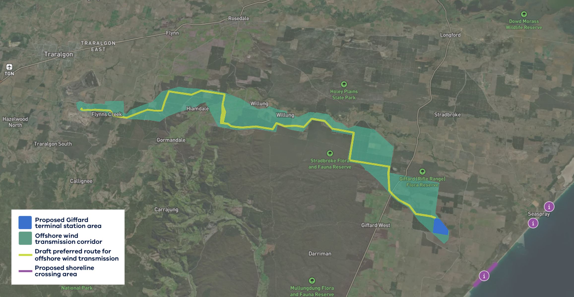
VicGrid is developing the shared transmission line to connect 2 gigawatts (GW) of offshore wind energy to the grid. The line will use 500 kilovolt (kV) double circuit overhead transmission technology, starting near Giffard and connecting to the Loy Yang Power Station switchyard.
Renewable energy transition video
Project status
Refining the study area to a corridor and draft preferred route
We've narrowed the broad study area down to a corridor and a draft preferred route – smaller areas that are most suitable for the transmission line.
This has involved:
- environmental and technical studies
- aerial surveys, biodiversity and habitat mapping
- feedback from landholders, Traditional Owners, technical experts and local communities and stakeholders.
VicGrid is also preparing an Environment Effects Statement (EES) to assess potential environmental, social, cultural and economic impacts. See Planning and environment for more information.
View our interactive map to provide input into what matters to you in the project area, and view the transmission corridor and draft preferred route.
Project activity
Current project activities provided by VicGrid regarding offshore wind transmission.
How offshore wind connects to the grid
Part of our role is to coordinate how offshore wind farms connect to the grid to minimise impacts on communities, Traditional Owners and the environment.
We have identified four areas along the Gippsland coast where offshore wind project developers can bring their transmission cables onshore to connect to the new offshore wind transmission line at the proposed Giffard terminal station area. The locations are:
- Reeves Beach
- McGauran Beach
- South-west of Merriman creek
- Seaspray Beach.
These locations were selected based on technical, environmental and land use considerations to help minimise potential impacts and coordinate the connection of multiple offshore wind projects.
The shoreline crossing areas are located within the draft Gippsland Shoreline Renewable Energy Zone. This is a limited area between the coast and the South Gippsland Highway where offshore wind developers will need to locate their underground cable routes to connect to the proposed terminal station in Giffard. This zone is not designed to host onshore wind or solar projects.
We’re now inviting submissions on the draft Gippsland Shoreline Renewable Energy Zone order, as part of a formal Ministerial process to declare the zone. This includes the shoreline crossing areas that are nominated in the draft Renewable Energy Zone order.
You can provide your feedback on Engage Victoria.
To view the shoreline crossing areas in more detail, visit our interactive map.
Who will deliver the transmission line?
VicGrid is running a competitive two-stage tender process to select a development partner to:
- design, build, finance, operate and maintain the transmission line and connection hub
- work closely with landholders, Traditional Owners and local communities
- deliver value for money for Victorian energy users.
After strong interest during the expression of interest phase, three consortia have been shortlisted. These consortia are now participating in the invitation to tender phase.
A development partner is expected to be appointed in 2026.
Our work so far
- In April 2023, we published the offshore wind transmission development and engagement roadmap, outlining next steps in planning new offshore wind transmission.
- In mid 2023, we used community feedback to refine the options assessment method, the decision-making tool we have used to inform our selection of the study area.
- In March 2024, we shared the study area and connection hub area. In response to feedback, the study area avoids major townships and includes a lower proportion of agricultural and private land than most other options, to minimise the impacts on smaller private landholders and farmers.
- In December 2024, we further refined the study area and ruled out certain locations, including Holey Plains State Park and areas near the Loy Yang Power Station.
Next steps
2025
- Continue EES technical assessments
2026 – 2027
- Identify a preferred route
- Exhibit the EES for public review
- Appoint a development partner
- Identify a transmission easement
- Planning and environmental approvals
- Commence early works
2027 – 2030
- Major construction and commissioning.
Page last updated: 02/04/26